Headlines From Our Twitter Feed

Showing posts with label weather. Show all posts

Wednesday, August 28, 2019

Hurricane Dorian

2 PM Advisory from the National Hurricane Center


BULLETIN
Hurricane Dorian Intermediate Advisory Number 17A
NWS National Hurricane Center Miami FL       AL052019
200 PM AST Wed Aug 28 2019

...DORIAN BECOMES A HURRICANE NEAR ST. THOMAS IN THE U.S. VIRGIN
ISLANDS...

...MULTIPLE OBSERVATIONS OF HURRICANE-FORCE WINDS IN ST. THOMAS...


SUMMARY OF 200 PM AST...1800 UTC...INFORMATION
----------------------------------------------
LOCATION...18.3N 65.0W
ABOUT 0 MI...0 KM W OF ST. THOMAS
MAXIMUM SUSTAINED WINDS...75 MPH...120 KM/H
PRESENT MOVEMENT...NW OR 315 DEGREES AT 13 MPH...20 KM/H
MINIMUM CENTRAL PRESSURE...997 MB...29.44 INCHES


WATCHES AND WARNINGS
--------------------

CHANGES WITH THIS ADVISORY:

The Tropical Storm Watch for the Dominican Republic has been
discontinued.

SUMMARY OF WATCHES AND WARNINGS IN EFFECT:

A Hurricane Warning is in effect for...
* Vieques and Culebra
* U.S. Virgin Islands
* British Virgin Islands

A Hurricane Watch is in effect for...
* Puerto Rico

A Tropical Storm Warning is in effect for...
* Puerto Rico

A Hurricane Warning means that hurricane conditions are expected
somewhere within the warning area, in this case within the next 6 to
12 hours.

A Hurricane Watch means that hurricane conditions are possible
within the watch area, in this case within the next 6 to 12 hours.
For storm information specific to your area in the United States,
including possible inland watches and warnings, please monitor
products issued by your local National Weather Service forecast
office. For storm information specific to your area outside of the
United States, please monitor products issued by your national
meteorological service.

DISCUSSION AND OUTLOOK
----------------------
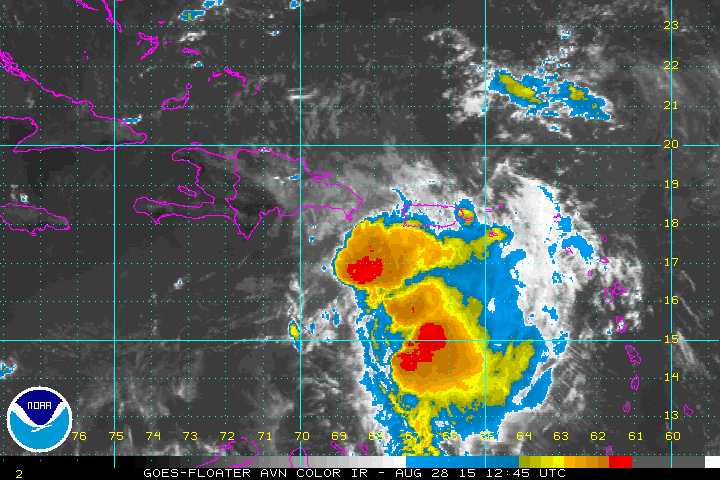
At 200 PM AST (1800 UTC), the center of Hurricane Dorian was located
near latitude 18.3 North, longitude 65.0 West. Dorian is moving
toward the northwest near 13 mph (20 km/h), and this motion is
expected to continue for the next day or two. On this track, Dorian
should continue to move near or over the U.S. and British Virgin
Islands this afternoon and then move over the open Atlantic well
east of the southeastern Bahamas.

Maximum sustained winds have increased to near 75 mph (120 km/h)
with higher gusts.  Dorian is forecast to continue strengthening
during the next few days over the Atlantic waters.
Hurricane-force winds extend outward up to 20 miles (30 km) to the
north and east of the center. Tropical-storm-force winds extend
outward up to 80 miles (130 km) primarily to the east of the center.
An elevated weather station on Buck Island just south of St. Thomas
reported a sustained wind of 82 mph (132 km/h) and a gust of 111 mph
(178 km/h).

The estimated minimum central pressure from nearby observations is
997 mb (29.44 inches).


HAZARDS AFFECTING LAND
----------------------
RAINFALL:  Dorian is expected to produce the following rainfall
accumulations:
Northern Leeward Islands...1 to 3 inches.
Eastern Puerto Rico, the Virgin Islands, and the northwest
Bahamas...4 to 6 inches, isolated 10 inches
Western Puerto Rico and the central Bahamas...2 to 4 inches
Coastal sections of the Southeast United States...4 to 8 inches,
isolated 10 inches. This rainfall may cause life-threatening flash floods.

WIND:  Hurricane conditions are ongoing over portions of the U.S.
Virgin Islands, and are expected over Vieques, Culebra, and the
British Virgin Islands today.  Tropical storm conditions are
expected in Puerto Rico this afternoon and tonight.
Wind speeds atop and on the windward sides of hills and mountains
are often up to 30 percent stronger than the near-surface winds
indicated in this advisory, and in some elevated locations could be
even greater.

SURF:   Swells are expected to increase later today across the U.S.
and British Virgin Islands and along the southern coasts of Puerto
Rico and Hispaniola, and they could cause life-threatening surf and
rip current conditions.  Please consult products from your local
weather office.

NEXT ADVISORY
-------------
Next complete advisory at 500 PM AST.
$$
Forecaster Avila


A map of storm shelters in Puerto Rico available ahead of #Dorian can be found at this link:


Thursday, July 5, 2018

Puerto Rico News Digest for July 5, 2018


TROPICAL STORM BERYL FORMS


According to the National Hurricane Center, Tropical Depression Two has now become Tropical Storm Beryl, the second tropical storm of the 2018 Atlantic hurricane season. According to the NHC's 2:30 PM AST update, the system reached maximum sustained winds of 40 mph early this afternoon, putting it in tropical storm status. As of this morning, the storm was expected to dissipate east of the Lesser Antilles sometime early next week. Keep checking this website and our Twitter feed  for any changes in the storm's status or forecast track. No watches or warnings have been issued so far. The latest stats on Beryl as of 3:45 PM AST are: 

LOCATION...10.3N 42.3W
ABOUT 1330 MI...2140 KM ESE OF THE LESSER ANTILLES
MAXIMUM SUSTAINED WINDS...40 MPH...65 KM/H
PRESENT MOVEMENT...W OR 275 DEGREES AT 16 MPH...26 KM/H
MINIMUM CENTRAL PRESSURE...1007 MB...29.74 INCHES


SENATE REJECTS REPEALING LAW 80


"Not even 24 hours after Rosselló called for an extraordinary session, the Senate rejected, for the third time, the bill that would repeal the compensation for unjustified dismissal act (Law 80-1976), and that would have allowed the  Government to comply with the agreement reached with the Oversight Board..."


PR GOVT TO CHALLENGE BOARD'S BUDGET IN COURT


"In a statement issued by his office, La Fortaleza, Puerto Rican Gov. Ricardo Rosselló announced Thursday that “the Government of Puerto Rico” was asking the court to “defend” the budget approved by the island’s legislature, which he signed, and decide whether it or the budget certified by the island’s fiscal oversight board should be implemented..."


PARTS OF EL YUNQUE FOREST TO REOPEN FOR SUMMER


"[Forest Service Interim Chief Vicki Christiansen]...announced that another area in the forest, Yokahu Tower, was to reopen to the public on July 4. In addition to Yokahu Tower, La Coca Falls along PR-191 and the Puente Roto and Angelito trails on road PR-988 are the few forest attractions available for visitors at this time..."


MAN SHOT TO DEATH IN CIDRA HOUSE


A still unidentified male was shot to death shortly after 2:00 AM today in the mountain town of Cidra. Local police were alerted to the shooting by a phone call, and upon arriving at the residence on Girasol Street, in the Campo Bello sector, found the bullet-riddled body of the victim inside his house. Caguas homicide detectives are investigating.

Tuesday, September 19, 2017

Hurricane Maria Coverage

OH, GOD...NOW WHAT?!?

DANGEROUS HURRICANE MARIA THREATENS PR


Hurricane Maria is expected to go through Puerto Rico, entering from the southeast, on Wednesday morning, even as the island is still dealing with the aftermath of its brush with Hurricane Irma little over a week ago. The latest National Hurricane Center bulletin is available below. Please keep checking our Twitter feed (featured below, after the bulletin) for the latest hurricane news.


BULLETIN
Hurricane Maria Advisory Number  16
NWS National Hurricane Center Miami FL       AL152017
1100 PM AST Tue Sep 19 2017

...EYE OF POTENTIALLY CATASTROPHIC CATEGORY 5 HURRICANE MARIA
NEARING ST. CROIX...
...CORE EXPECTED TO REACH SOUTHEASTERN PUERTO RICO WEDNESDAY
MORNING...


SUMMARY OF 1100 PM AST...0300 UTC...INFORMATION
-----------------------------------------------
LOCATION...17.3N 64.7W
ABOUT 30 MI...45 KM SSE OF ST. CROIX
ABOUT 120 MI...190 KM SE OF SAN JUAN PUERTO RICO
MAXIMUM SUSTAINED WINDS...175 MPH...280 KM/H
PRESENT MOVEMENT...WNW OR 300 DEGREES AT 10 MPH...17 KM/H
MINIMUM CENTRAL PRESSURE...909 MB...26.85 INCHES


WATCHES AND WARNINGS
--------------------
CHANGES WITH THIS ADVISORY:

None

SUMMARY OF WATCHES AND WARNINGS IN EFFECT:

A Hurricane Warning is in effect for...
* U.S. Virgin Islands
* British Virgin Islands
* Puerto Rico, Culebra, and Vieques
* Dominican Republic from Cabo Engano to Puerto Plata


From our Twitter feed:


Tuesday, September 5, 2017

Hurricane Irma Coverage

A MONSTER APPROACHES

IRMA NOW A STRONG CAT 5 STORM


For the latest on Irma, check out our Twitter feed. 

Scroll down past tweets below for the National Hurricane Center's Advisory.  


Latest from the National Hurricane Center as of 11 PM AST:


BULLETIN
Hurricane Irma Advisory Number  28
NWS National Hurricane Center Miami FL       AL112017
1100 PM AST Tue Sep 05 2017

...POTENTIALLY CATASTROPHIC CATEGORY 5 HURRICANE IRMA GETTING VERY
CLOSE TO THE NORTHERN LEEWARD ISLANDS...


SUMMARY OF 1100 PM AST...0300 UTC...INFORMATION
-----------------------------------------------
LOCATION...17.4N 61.1W
ABOUT 50 MI...80 KM ENE OF ANTIGUA
ABOUT 50 MI...75 KM ESE OF BARBUDA
MAXIMUM SUSTAINED WINDS...185 MPH...295 KM/H
PRESENT MOVEMENT...WNW OR 285 DEGREES AT 15 MPH...24 KM/H
MINIMUM CENTRAL PRESSURE...916 MB...27.05 INCHES


WATCHES AND WARNINGS
--------------------
CHANGES WITH THIS ADVISORY:

None.

SUMMARY OF WATCHES AND WARNINGS IN EFFECT:

A Hurricane Warning is in effect for...
* Antigua, Barbuda, Anguilla, Montserrat, St. Kitts, and Nevis
* Saba, St. Eustatius, and Sint Maarten
* Saint Martin and Saint Barthelemy
* British Virgin Islands
* U.S. Virgin Islands
* Puerto Rico, Vieques, and Culebra
* Dominican Republic from Cabo Engano to the northern border with
Haiti
* Guadeloupe

A Hurricane Watch is in effect for...
* Haiti from the northern border with the Dominican Republic to Le
Mole St. Nicholas
* Turks and Caicos Islands
* Southeastern Bahamas
* Cuba from Matanzas province eastward to Guantanamo province

A Tropical Storm Warning is in effect for...
* Dominica
* Dominican Republic from south of Cabo Engano westward to the
southern border with Haiti

A Tropical Storm Watch is in effect for...
* Haiti from south of Le Mole St. Nicholas to Port-Au-Prince

A Hurricane Warning means that hurricane conditions are expected
somewhere within the warning area.  Preparations to protect life and
property should be rushed to completion.

A Hurricane Watch means that hurricane conditions are possible
within the watch area.  A watch is typically issued 48 hours
before the anticipated first occurrence of tropical-storm-force
winds, conditions that make outside preparations difficult or
dangerous.

A Tropical Storm Warning means that tropical storm conditions are
expected somewhere within the warning area.

A Tropical Storm Watch means that tropical storm conditions are
possible within the watch area, generally within 48 hours.

Interests elsewhere in the Dominican Republic and Haiti, as
well as Cuba, the central and northwestern Bahamas, and Florida
should monitor the progress of Irma.

For storm information specific to your area in the United
States, including possible inland watches and warnings, please
monitor products issued by your local National Weather Service
forecast office. For storm information specific to your area outside
the United States, please monitor products issued by your national
meteorological service.


DISCUSSION AND 48-HOUR OUTLOOK
------------------------------
At 1100 PM AST (0300 UTC), the eye of Hurricane Irma was located
near latitude 17.4 North, longitude 61.1 West.  Irma is moving
toward the west-northwest near 15 mph (24 km/h), and this motion is
expected to continue for the next couple of days.  On the forecast
track, the extremely dangerous core of Irma will move over portions
of the northern Leeward Islands tonight and early Wednesday, move
near or over portions of the northern Virgin Islands Wednesday, and
pass near or just north of Puerto Rico late Wednesday and Wednesday
night.

Maximum sustained winds remain near 185 mph (295 km/h) with higher
gusts.  Irma is a category 5 hurricane on the Saffir-Simpson
Hurricane Wind Scale.  Some fluctuations in intensity are likely
during the next day or two, but Irma is forecast to remain a
powerful category 4 or 5 hurricane during the next couple of days.

Hurricane-force winds extend outward up to 50 miles (85 km) from the
center and tropical-storm-force winds extend outward up to 175 miles
(280 km).

The minimum central pressure estimated from Air Force and NOAA
Hurricane Hunter aircraft observations is 916 mb (27.05 inches).


HAZARDS AFFECTING LAND
----------------------
STORM SURGE:  The combination of a life-threatening storm surge and
large breaking waves will raise water levels ABOVE NORMAL TIDE
LEVELS by the following amounts within the hurricane warning area
near and to the north of the center of Irma.  Near the coast, the
surge will be accompanied by large and destructive waves.

Northern Leeward Islands...7 to 11 ft
Turks and Caicos Islands...15 to 20 ft
Southeastern Bahamas...15 to 20 ft
Northern coast of the Dominican Republic...3 to 5 ft
Northern coast of Haiti and the Gulf of Gonave...1 to 3 ft

The combination of a life-threatening storm surge and the tide will
cause normally dry areas near the coast to be flooded by rising
waters moving inland from the shoreline.  The water is expected to
reach the following HEIGHTS ABOVE GROUND if the peak surge occurs at
the time of high tide...

British and U.S. Virgin Islands except St. Croix...7 to 11 ft
Northern coast of Puerto Rico...3 to 5 ft
Southern coast of Puerto Rico and St. Croix...1 to 2 ft

The deepest water will occur along the immediate coast in areas of
onshore winds, where the surge will be accompanied by large and
destructive waves.  Surge-related flooding depends on the relative
timing of the surge and the tidal cycle, and can vary greatly over
short distances.  For information specific to your area, please see
products issued by your local National Weather Service forecast
office.

WIND:  Hurricane conditions are expected within the hurricane
warning area in the Leeward Islands tonight, with tropical storm
conditions beginning within a couple of hours.  Hurricane
conditions are expected to begin within the hurricane warning area
in the British and U.S. Virgin Islands and Puerto Rico on Wednesday,
with tropical storm conditions beginning tonight.  Hurricane
conditions are expected to begin within the hurricane warning area
in the Dominican Republic early Thursday, with tropical storm
conditions beginning Wednesday night.

Hurricane and tropical storm conditions are possible within the
watch area in Haiti, the Turks and Caicos Islands, and the
southeastern Bahamas by early Thursday.

RAINFALL:  Irma is expected to produce the following rain
accumulations through Thursday:

Northern Leeward Islands...8 to 12 inches, isolated 20 inches
Northeast Puerto Rico and the British and U.S. Virgin Islands
except St. Croix...4 to 10 inches, isolated 15 inches
Southwest Puerto Rico, the southern Leeward Islands, and
St. Croix...2 to 4 inches

Irma is expected to produce the following rain accumulations
Wednesday through Saturday:

Southeast Bahamas and Turks and Caicos...8 to 12 inches, isolated 20
inches
Northern Dominican Republic and northern Haiti...4 to 10 inches,
isolated 15 inches
Southwest Haiti...1 to 4 inches

These rains could cause life-threatening flash floods and mudslides.

SURF:  Swells generated by Irma will affect the northern Leeward
Islands, Puerto Rico, the Virgin Islands, the southeastern Bahamas,
the Turks and Caicos Islands, and the northern coast of the
Dominican Republic during the next several days.  These swells are
likely to cause life-threatening surf and rip current conditions.
Please consult products from your local weather office.


NEXT ADVISORY
-------------
Next intermediate advisory at 200 AM AST.
Next complete advisory at 500 AM AST.

$$
Forecaster Pasch


Monday, September 4, 2017

Hurricane Irma Menaces Puerto Rico


Monitor our Twitter feed for the latest on Irma


From Caribbean Business:

"Hurricane Irma grew into a powerful Category 4 storm Monday as it approached the northeastern Caribbean and was forecast to begin buffeting the region Tuesday...Emergency officials warned that the storm could dump up to 10 inches (25 centimeters) of rain, unleash landslides and dangerous flash floods and generate waves of up to 23 feet (7 meters) as the storm drew closer...
“We’re looking at Irma as a very significant event,” Ronald Jackson, executive director of the Caribbean Disaster Emergency Management Agency, said by phone. “I can’t recall a tropical cone developing that rapidly into a major hurricane prior to arriving in the central Caribbean...”
____________________________________________________________

The latest from the National Hurricane Center is below:
Hurricane Irma Advisory Number  23
NWS National Hurricane Center Miami FL       AL112017
1100 PM AST Mon Sep 04 2017

...HURRICANE WARNINGS ISSUED FOR PUERTO RICO AND THE VIRGIN
ISLANDS...


SUMMARY OF 1100 PM AST...0300 UTC...INFORMATION
-----------------------------------------------
LOCATION...16.7N 55.6W
ABOUT 410 MI...660 KM E OF THE LEEWARD ISLANDS
MAXIMUM SUSTAINED WINDS...140 MPH...220 KM/H
PRESENT MOVEMENT...W OR 270 DEGREES AT 13 MPH...20 KM/H
MINIMUM CENTRAL PRESSURE...943 MB...27.85 INCHES


WATCHES AND WARNINGS
--------------------
CHANGES WITH THIS ADVISORY:

The Hurricane Watch for the U.S. Virgin Islands, Puerto Rico,
Vieques, and Culebra has been changed to a Hurricane Warning.

The government of Antigua has changed the Hurricane Watch for the
British Virgin Islands to a Hurricane Warning.

SUMMARY OF WATCHES AND WARNINGS IN EFFECT:

A Hurricane Warning is in effect for...
* Antigua, Barbuda, Anguilla, Montserrat, St. Kitts, and Nevis
* Saba, St. Eustatius, and Sint Maarten
* Saint Martin and Saint Barthelemy
* British Virgin Islands
* U.S. Virgin Islands
* Puerto Rico, Vieques, and Culebra

A Hurricane Watch is in effect for...
* Guadeloupe

A Tropical Storm Warning is in effect for...
* Guadeloupe

A Tropical Storm Watch is in effect for...
* Dominica

A Hurricane Warning means that hurricane conditions are expected
somewhere within the warning area.  A warning is typically issued
36 hours before the anticipated first occurrence of tropical-storm-
force winds, conditions that make outside preparations difficult or
dangerous.  Preparations to protect life and property should be
rushed to completion.

A Hurricane Watch means that hurricane conditions are possible
within the watch area.  A watch is typically issued 48 hours before
the anticipated first occurrence of tropical-storm-force winds,
conditions that make outside preparations difficult or dangerous.

A Tropical Storm Warning means that tropical storm conditions are
expected somewhere within the warning area within 36 hours.

A Tropical Storm Watch means that tropical storm conditions are
possible within the watch area, generally within 48 hours.

Interests in the Dominican Republic, Haiti, the Turks and Caicos
Islands, Cuba, and the southeastern and central Bahamas should
monitor the progress of Irma.


DISCUSSION AND 48-HOUR OUTLOOK
------------------------------
At 1100 PM AST (0300 UTC), the eye of Hurricane Irma was located
by an Air Force Hurricane Hunter aircraft near latitude 16.7 North,
longitude 55.6 West.  Irma is moving toward the west near 13 mph (20
km/h) and this general motion is expected to continue into Tuesday,
followed by a turn toward the west-northwest late Tuesday.  On the
forecast track, the center of Irma will move near or over portions
of the northern Leeward Islands Tuesday night and early Wednesday.

Maximum sustained winds are near 140 mph (220 km/h) with higher
gusts.  Irma is a category 4 hurricane on the Saffir-Simpson
Hurricane Wind Scale.  Additional strengthening is forecast during
the next 48 hours.

Hurricane-force winds extend outward up to 45 miles (75 km) from the
center and tropical-storm-force winds extend outward up to 140 miles
(220 km).

The minimum central pressure estimated from Hurricane
Hunter observations is 943 mb (27.85 inches).


HAZARDS AFFECTING LAND
----------------------
STORM SURGE:  The combination of a dangerous storm surge and large
breaking waves will raise water levels by as much as 6 to 9 feet
above normal tide levels along the coasts of the extreme northern
Leeward Islands within the hurricane warning area near and to the
north of the center of Irma.  Near the coast, the surge will be
accompanied by large and destructive waves.

The combination of a dangerous storm surge and the tide will cause
normally dry areas near the coast to be flooded by rising waters
moving inland from the shoreline.  The water is expected to reach
the following heights above ground if the peak surge occurs at the
time of high tide...

British and U.S. Virgin Islands except St. Croix...4 to 6 ft
Northern coast of Puerto Rico...2 to 4 ft
Southern coast of Puerto Rico and St. Croix...1 to 2 ft

The deepest water will occur along the immediate coast in areas of
onshore winds, where the surge will be accompanied by large and
destructive waves.  Surge-related flooding depends on the relative
timing of the surge and the tidal cycle, and can vary greatly over
short distances.  For information specific to your area, please see
products issued by your local National Weather Service forecast
office.

WIND:  Hurricane conditions are expected within the hurricane
warning area by Tuesday night, with tropical storm conditions
expected by late Tuesday.  Hurricane conditions are possible within
the hurricane watch area in the Virgin Islands and Puerto Rico by
late Wednesday, with tropical storm conditions possible by early
Wednesday.  Tropical Storm conditions are expected within the
tropical storm warning area by late Tuesday.

RAINFALL:  Irma is expected to produce total rainfall accumulations
of 3 to 6 inches with isolated maximum amounts of 10 inches across
the northern Leeward Islands, the British and U.S. Virgin Islands,
and Puerto Rico.  These rainfall amounts may cause life-threatening
flash floods and mudslides.

SURF:  Swells generated by Irma will affect the northern Leeward
Islands, Puerto Rico, and the U.S. and British Virgin Islands
during the next several days.  These swells are likely to cause
life-threatening surf and rip current conditions. Please consult
products from your local weather office.


NEXT ADVISORY
-------------
Next intermediate advisory at 200 AM AST.
Next complete advisory at 500 AM AST.

Thursday, August 3, 2017

NWS Monitors Weather System In East Atlantic


From The National Hurricane Center:

Tropical Weather Outlook
NWS National Hurricane Center Miami FL
800 AM EDT Thu Aug 3 2017

For the North Atlantic...Caribbean Sea and the Gulf of Mexico:

A large area of showers and thunderstorms centered about 500 miles
southeast of the Cabo Verde Islands is associated with a vigorous
tropical wave. Environmental conditions are forecast to be conducive
for gradual development, and a tropical depression could form by
early next week over the eastern or central tropical Atlantic
Ocean. This system is forecast to move toward the west or
west-northwest at 10 to 15 mph for the next several days.
* Formation chance through 48 hours...low...30 percent.
* Formation chance through 5 days...medium...60 percent.


Tuesday, October 4, 2016

Puerto Rico News Digest For October 4, 2016


WEATHER SYSTEM COULD BECOME STORM


F


From The National Hurricane Center:

"Showers and thunderstorms continue in association with a low pressure area 
located about 500 miles northeast of Puerto Rico. Satellite wind data indicate 
that the low is producing winds to gale force, and the system could become su-
fficiently well organized to result in the formation of a tropical storm later today.  
The low is expected to move generally northwestward at 10 to 15 mph over the 
next few days, and upper-level winds are forecast to become less conducive for 
development. Formation chance through 48 hours...high...80 percent. Formation 
chance through 5 days...high...80 percent..."


BOARD SETS DEADLINE FOR TURNAROUND PLAN


From The San Juan Daily Star:

"Puerto Rico’s newly created federal oversight board on Friday set an Oct.14
deadline for the island’s governor to draft a fiscal turnaround plan, as protesters
at its first public meeting compared the board to “slavery” and said it was “pilla-
ging Puerto Rico.” The board asked Gov. Alejandro García Padilla to present a
plan laying out his vision for stabilizing Puerto Rico, which is grappling with $70
billion in debt, a 45 percent poverty rate and a decade-long recession..."


DONAHUE TO TESTIFY ABOUT BLACKOUT


From Caribbean Business:

"The Senate Committee on Energy and Water Resources has summoned the ch-
ief restructuring officer of the Puerto Rico Electric Power Authority (Prepa), Li-
sa Donahue, to appear Tuesday as part of the hearings that began last week to in-
vestigate the possible reasons that led to the collapse the electrical system on Sep-
tember 21 and the delay in the restoration of electrical service. The president of the
committee, Popular Democratic Party Sen. Ramón Luis Nieves, said that Donahue
should give details before the Senate panel about the work done by her firm, Alix
Partners, since it was hired by Prepa in September 2014 to restructure the utility’s
debt and transform the operations of the public corporation..."


CUSTOMS SEIZES $1.5M IN COUNTERFEIT GOODS


From News Is My Business:


"U.S. Customs and Border Protection San Juan Field Operations announced today
that 206 seizures where made of counterfeit products, valued at $1.5 million, wh-
ich were illegally imported into Puerto Rico via international mail. A wide range
of counterfeited products was seized during the enforcement effort, called “Oper-
ation Silver Snake 2,” to include: consumer products, apparel, footwear, textiles,
pharmaceuticals, and more, the agency said. Various international mail packages
inspected by CBP officers at the San Juan International Mail Branch revealed pro-
ducts that infringedintellectual property rights. The majority of the seized products
originated in China, the agency said..."


Tuesday, September 6, 2016

Puerto Rico News Digest For September 6, 2016


HIGH WINDS KILL MAN IN GUAYANILLA


From Caribbean Business:

"Authorities say heavy winds associated with a tropical wave moving through the
Caribbean region have killed a man in the island’s southwest region. Police said
Monday that winds ripped off a tree branch that hit 31-year-old Alvin Torres as
he cleaned a property in the coastal town of Guayanilla. Forecasters said the tro-
pical wave south of Puerto Rico was generating winds of up to 40 miles per hour
(mph)...The National Hurricane Center (NHC) said Monday that shower and thu-
nderstorm activity associated with the wave had been decreasing. However, “stro-
ng winds, possibly to tropical storm force, could still be occurring in association
with this system” over Puerto Rico and Hispaniola Monday and Tuesday..."


NATL GUARD LANGUAGE CENTER OPEN THROUGH 2017


From The San Juan Daily Star:

"Resident Commissioner Pedro Pierluisi announced last week that the effort he
has led since 2014 to prevent the closure of the English Language Center opera-
ted by the Puerto Rico National Guard (PRNG) at Ft. Allen in Juana Díaz "appe-
ars to be on a successful path.” The English Language Center was scheduled to
be closed starting in fiscal year (FY) 2016, which ended June 30, but Pierluisi’s
efforts resulted in the Language Center continuing to operate..."


PR DEMANDS EPA CLEAN UP TOXIC LANDFILLS


From Washington Examiner:

"Puerto Ricans, disgusted with the Environmental Protection Agency's "willful
dereliction" of its oversight of the island's toxic landfills, are demanding that the
head of the agency close them, saying they have lost faith in an EPA deputy in
charge of the territory. The citizens' advocacy group Puerto Rico Limpio, which
means Puerto Rico Clean, is clamoring in a letter for EPA Administrator Gina Mc
Carthy to enforce federal laws by closing the "toxic landfills." Their Sept. 1 letter
spells out a "shocking pattern of willful dereliction of federal responsibility" by E-
PA Regional 2 Administrator Judith Enck, who in newly released documents was
dismissive of the group's concerns, saying the agency took care of the problem
over the last decade..."


PR BANKRUPTICES UP 8.14% IN AUGUST


From News Is My Business:

"The number of bankruptcy cases filed in Puerto Rico was up 8.14 percent year-
over-year in August, when 929 cases were filed. So far this year, 7,038 petitions
have been filed at the U.S. Bankruptcy Court, representing a 4.25 percent jump
when compared to the same period last year, information provided by research
firm Boletín de Puerto Rico showed..."


Friday, July 29, 2016

Puerto Rico News Digest For July 29, 2016


TWO MURDERS REPORTED THIS MORNING


As reported by El Nuevo Día, two separate murders were registered in Puer-
to Rico this morning, with the first one occuring at around 12:52 AM at the 
Placita de Santurce in San Juan. After callers reported shots heard in the vic-
inity, Police found the body of 44-year old Mario Díaz Pérez, whose body was 
riddled with bullets. The second killing occured at around 8:11 AM this morn-
ing in the Barahona sector of Morovis, on Road PR-633. Police have yet to id-
entify the victim or release any other information. 


TROPICAL WAVE TO BRING WEEKEND RAIN


"The National Hurricane Center (NHC) in Miami says a tropical wave, loca-
ted about 1200 miles east of the Lesser Antilles is moving westward at about 
25 mph. The associated shower activity is poorly organized, “and given the 
fast motion of the system any development should be slow to occur..." The 
chance of it forming into a tropical cyclone through the next 48 hours is low 
at 20 percent. Its formation chance through five days is still considered low 
but rises to 30 percent..."


PIP CANDIDATE DEFENDS PUBLIC EDUCATION


From The San Juan Daily Star:

"Puerto Rican Independence Party (PIP) gubernatorial candidate María de
Lourdes Santiago said Wednesday that as part of her electoral proposal, pu-
blic education must become the great democratizing element  and the most
important investment of a society in which public schools are faced with a
systematic campaign of discrediting and abandonment. “The public Depart-
ment of Education has been the object of a systematic campaign of discredi-
ting to pave the way for privatization,” Santiago said in a press conference
at PIP headquarters in Hato Rey, in which she told of a shortage of materials
and books despite a $3.2 billion budget..."


TREASURY REPORTS 2% REVENUE INCREASE


"The Puerto Rico Treasury Department collected some $9.1 billion in reve-
nue for the General Fund during Fiscal 2016, exceeding Fiscal 2015 numbers 
by $214.4 million or 2.4 percent, agency Secretary Juan Zaragoza-Gómez said. 
The increase was much greater considering that last year, there were revenues 
from legislative measures of nearly $468 million that were not recurrent for FY 
2015-16, he said. When comparing the revenue registered for the year to the re-
vised total estimate of $9.2 billion, the government achieved a 98.7 percent co-
llections rate..." 


Wednesday, June 1, 2016

Puerto Rico News Digest For June 1, 2016


HURRICANE SEASON STARTS TODAY


From The San Juan Daily Star:

"U.S. government forecasters expect a near-normal Atlantic hurricane season,
after three relatively slow years. But they also say climate conditions that influ-
ence storm development are making it difficult to predict how many hurricanes
and tropical storms will arise over the next six months. The National Oceanic
and Atmospheric Administration’s outlook released late last week called for a
near-normal season with 10 to 16 named storms, with four to eight hurricanes
and one to four “major” ones with winds reaching 111 mph and up..."


SENATE HONORS VETS ON MEMORIAL DAY


From Caribbean Business:

"The Senate received Monday a group of veterans and their families, as well as
officers, to commemorate Memorial Day in a ceremony at a Capitol monument
honoring the fallen in various wars. Sen. Miguel Pereira, chairman of the Judici-
ary, Security and Veterans Committee, hosted the activity and received Col. Mar-
ta Carcana, adjutant general of the National Guard of Puerto Rico, who delivered
a message to attendees. Also attending the ceremony were Jorge Cases, spokes-
man for the Veterans Advocate Office; former Puerto Rico National Guard Adjt.
Gen. Luis González Vale and former San Juan Mayor Héctor Luis Acevedo, who
retired as a lieutenant colonel from the U.S. Army Reserve in 1998..."


OMB: PAYING DEBT COULD MEAN LAYOFFS


From News Is My Business:

"If the government of Puerto Rico were to pay the full amount due next year in
GO debt would require laying off more than 3,400 public workers, among other
adjustments, Luis Cruz, executive director of the Office of Management and Bud-
get, told members of the House Finance Committee during budget hearings Mon-
day. In his testimony, Cruz said the $209 million set aside from the General Fund
will go to cover GO interest payment, but no principal amount, which would total
$1.4 billion next fiscal year..."


SAN JUAN TAXI DRIVERS PROTEST UBER


From Fox News Latino:

"Traffic chaos prevailed in San Juan on Tuesday as taxi drivers and  truckers
protested the arrival in Puerto Rico of Uber, the private ride-hailing service,
which links passengers and drivers via a mobile application. On Tuesday mor-
ning it was difficult to find taxis on the capital streets, while some tourist excur-
sions had to be cancelled when drivers with certain tourist operators refused to
work..."


Monday, October 5, 2015

Puerto Rico News Digest For October 5, 2015


TRACES FOUND OF MISSING SHIP


From Fox News Latino:

Aircraft and ships searching off the Bahamas islands for a U.S. cargo ship
that lost contact during Hurricane Joaquin have found more debris and clues
but no definitive word yet on the fate of the vessel or the 33 people on board.
The owner of the 790-foot El Faro said a container that appears to have come
from the ship was found, while the Coast Guard said it had located a debris
field that included what appeared to be pieces of container. Searchers have
also spotted an oil sheen and found a life ring from the El Faro. Chief Petty
Officer Bobby Nash said it was too early to come to any conclusion. Two
Coast Guard cutters, the Northland and Resolute, were expected to continue
searching overnight Sunday as the aircraft returned to their bases.


POLICE SEIZE $5.4 MILLION DRUG SHIPMENT


From Caribbean Business:

"Authorities are searching for three suspects who allegedly attempted to
smuggle $5.4 million worth of drugs into Puerto Rico from the Dominican
Republic. Police said they arrested Teófilo Tineo González, a 36-year-old
Dominican man, after seizing about 518 pounds (235 kilograms) of cocai-
ne and heroin and a 22-foot (6.7-meter) boat on the coast west  of San Juan,
but three other suspects got away. Police Superintendent José Caldero said
authorities were hunting for three others they believe were aboard the boat
that left the Dominican Republic for Puerto Rico on Wednesday night..."


RESERVOIR LEVELS GO UP OVER THE WEEKEND


Rains over this past weekend have raised the water level at the Carraízo and
La Plata reservoirs, both of which serve the bulk of the San Juan metro area.
La Plata went up by 47 centimeters from Sunday morning to Monday morn-
ing, for a level of 40.50 meters. La Plata's users, however, are  still a ways
away from being taken off the current 24-hour water rationing plan they are
currently under. The reservoir would have to reach at least 43 meters for ra-
tioning to be discontinued. The Carraízo reservoir saw its water level rise over
the weekend to 38.47 meters, staving off for now a return to a rationing plan
for its 160,000 users. Its level rose by 26 centimeters from Sunday to Monday.


EPA FINALIZES PLAN FOR CONTAMINATED WELL


From The San Juan Daily Star:

The U.S. Environmental Protection Agency (EPA) finalized a plan to use
natural processes along with the continued use of a system that the federal
agency had already installed to treat contaminated groundwater at the Coro-
zal Well Superfund Site in Corozal, officials announced Thursday. Previou-
sly, the EPA installed a system that uses carbon to address pollutants as an
initial step to address the risks posed by people drinking contaminated gro-
undwater. Data collected since EPA installed the system confirms that there
are no levels of concern at the well. The system will remain in place as a sa-
feguard.


Thursday, September 24, 2015

La Plata Water Rationing Cut To 24 Hours


Starting tomorrow, the 180,000  water users served by the La Plata reservoir
will see their water rationing plan cut from 48 hours without running water at
a time down to 24 hour cut-offs. This is due to La Plata's water level having
risen by 1.11 meters due to heavy rains yesterday. Between one and four in-
ches of rain fell across the island on Wednesday. With the reservoir's level
sitting as of today at 39.94 meters, it is about 11 meters away from its opti-
mal level. La Plata serves the towns of Bayamón, Guaynabo, Cataño, Toa
Baja and  Toa Alta as well as parts of San Juan, Corozal, Naranjito and Do-
rado.

Meanwhile, the Carraízo reservoir has seen significant drops in its water lev-
els since rationing was lifted for customers served by that body of water. It is
currently at 38.65 meters. Some scattered showers are expected over Puerto
Rico over the next couple of days.


Friday, August 28, 2015

Tropical Storm Erika Aftermath


Erika skirted Puerto Rico's southern coast overnight, leaving behind
less damage, and less rain, than anticipated. Across most of the island,
between 1 and 3 inches of rain have been registered, which raised the
level of the Carraizo reservoir by 45 centimeters and La Plata's level
by 22 centimeters. A bit more rain is expected, and the morning is
still relatively windy. But for the most part, the weather event is ess-
entially over. It will be over for good around noon today.

As of this morning, about 246,000 households are without electrical
power, and around 250 people sought refuge in shelters across the
island. There are some downed trees and other moderate wind damage
across Puerto Rico, especially in the south. Damage was minimal
around the San Juan area, where there is little traffic this morning.
Road PR-167 through Comerio is still shut down. It was closed yes-
terday as a preventive measure. Many flights out of San Juan's main
airport remain cancelled, but the airport is open. The 'Dry Law' and
price controls will expire at 10:00 AM today.

Tropical Storm Erika is now affecting the Dominican Republic
and is expected to head towards Florida next.


Thursday, August 27, 2015

Tropical Storm Erika Coverage


Good morning, Puerto Rico. Keep checking this post throughout the
day and night today for information on Tropical Storm Erika, inclu-
ding closings, power outages, flooding, etc. If you have any infor-
mation you would like us to post, please leave it in the comments
section below or email us at embillpublishing@gmail.com. We al-
so encourage you to check our Twitter feed.

____________________________________________________________


9:25 PM: It seems like southern PR is still poised to take the
worst of Erika, after earlier forecasts had placed it closer to the
island's northeast, including Vieques and Culebra. Now it seems
like Ponce will take a direct hit from the storm's center (such
as it is). However, tropical storm force winds will be felt all 
across Puerto Rico until about noon tomorrow, and the rain will
then hang around for a little while after that. It is recommended
everyone stay inside until at least tomorrow evening and avoid
any unnecessary travel.

Strong winds have been felt already in the US Virgin Islands, and
the rain and wind are picking up in Vieques. The streets of the San
Juan metro area are eerily quiet as people hunker down in anticipa-
tion of worse weather.


Ferries between Fajardo & Vieques/Culebra will still be suspen-
ded tomorrow.


5:58 PM: We are now taking a break. We'll be back with updates
at around 9:00 PM ADT or sooner.

5:55 PM: Erika now expected to enter PR between Santa Isabel
and Ponce overnight, at abut 1 AM. San Juan will be very windy
around 11 PM. Storm will leave the local area at around 2 PM
tomorrow. 4-8 inches of rain forecast. Aír Europa, Jet Blue, Sea-
borne &  US Airways cancel flights. PR Government employees
will not be working tomorrow. No classes at public schools and 
courts will be closed. 

5:09 PM: A couple of items...Per US Coast Guard, all ports around
PR are closed. Also, there are no classes tomorrow at ANY of the
UPR campuses.

4:46 PM: 5 PM Nat'l Weather Svc advisory is out. Erika is finally
starting to take a turn towards the west/northwest, with a slight
slowing in forward speed to 15 mph. Max. sustained winds still
holding at 45 mph, barely tropical storm strength. Again, the real
danger with Erika will be the rain.

4:32 PM: Over 10,000 households reportedly without electrical
power already across the island.

4:28 PM: University of Puerto Rico Rio Piedras has announced
that there will be no classes or administrative activities tomorrow.
It's probably safe to say this will apply to all UPR campuses, but
so far announcement only applies to Rio Piedras.

2:15 PM: Latest Erika satellite image:


1:43 PM: Now four are reported dead in Dominica due to Erika. Se-
veral people missing as well.

1:18 PM: Several public schools around Puerto Rico are being opened
to serve as shelters. Ernesto Ramos Antonini in Ponce is one of them.
Trying to obtain a list of more, will post here if we can find one. You
can call 3-1-1 or 787-723- 7707 for shelter information.

12:52 PM: Governor Padilla holds press conference, urges preparedness.
'Dry law' in effect from noon today to noon tomorrow, hotels/resorts
are exempt. Up to 12" of rain now expected to fall on the island due to
revised track.

12:42 PM: Government employees left work for the day within the last
hour. Lots of traffic around SJ metro area and beyond.

11:40 AM: Puerto Rico's consumer affairs agency, DACO, froze prices
for essential goods effective last night. This includes gas. Don't get
ripped off!

11:10 AM: From 11 AM advisory:

LOCATION...16.4N 63.3W
ABOUT 125 MI...205 KM W OF GUADELOUPE
MAXIMUM SUSTAINED WINDS...50 MPH...85 KM/H
PRESENT MOVEMENT...W OR 270 DEGREES AT 16 MPH...26 KM/H
MINIMUM CENTRAL PRESSURE...1006 MB...29.71 INCHES

10:50 AM: These airlines have cancelled flights: Cape Air, Trade-
wind & Seaborne.

10:35 AM: Looking rainy in Vieques...


10:30 AM: Three people dead in the Caribbean island of Dominica
in the wake of Erika's passing.

9:23 AM: 'Dry Law' will go into effect at noon today. If you want
to buy liquor, you'd better do it before then.

9:18 AM: American Airlines and US Airways expected to shut down
operations at Luis Muñoz Marín Int'l Airport at 6:00 PM today. Flights
to Florida over the weekend could be affected as well, since the storm
is expected to head in that direction.

9:10 AM: Govenor Padilla has activated the National Guard. Catholic
University of Ponce is suspending classes at noon today.

____________________________________________________________


Wednesday, August 26, 2015

Closings And Postponements Due To Erika


This page will be updated as new information comes in. Below are closings
and postponements happening tomorrow due to the expected passage of
Tropical Storm Erika.

** Dozens of flights out of San Juan's LMM Airport have been cancelled
     or delayed. Contact your airline before leaving for the airport. ** 

* Puerto Rico government offices and public schools in eastern part
   of Puerto Rico will be closed tomorrow and open until noon in 
   the rest of the island.

* Vieques/Culebra ferries from Fajardo: last ferry will leave Fajardo at 4:00
   AM Thursday. Last ferries from Vieques and Culebra will leave at 10:00
   AM.  After that, ferries will not operate again until further notice.

* Arecibo Observatory: Closed tomorrow and Friday.

* Amnesty International's screening of “Citizens of Nowhere” postponed until
   further notice.

* San Jose and Puerto Nuevo Diagnostic & Treatment Centers will remain
   open tomorrow for as long as weather conditions allow.

* San Juan non-emergency city employees are being advised to not come to
   work on Thursday. City offices will therefore be closed.

* El Yunque National Forest will be closed tomorrow. It may reopen Friday
   depending on conditions.

* The Bacardi Distillery in Cataño will be closed tomorrow Thursday.

* Instituto de Banca y Comercio: night classes cancelled tomorrow. Friday's
   schedule depends on conditions.

* National University College: No NIGHT classes Thursday. Friday's schedule
   depends on conditions.

* University of Puerto Rico, ALL Campuses: No classes or administrative activities
   on Thursday.

* Universidad Central de Bayamón: No classes Thursday.

* All Catholic schools in the Diocese of  Fajardo-Humacao: No class Thursday

* Colegio Bautista de Caguas: No class Thursday.

* San Juan YMCA: Closed tomorrow Thursday.

* Ana G. Méndez University System (All Schools) - Closing at 3:00 PM on
   Thursday. UPDATE: Classes will end at noon on Thursday now.

* Oriental Bank: Branches in Ceiba, Humacao, Las Piedras & Yabucoa open
   tomorrow 8:30 AM -10:30 AM. Other branches open until 3:00 PM.

* Sagrado Corazon University will end classes at noon Thursday.

* Universidad Interamericana will end classes at noon Thursday.


__________________________________________________________________


Puerto Rico News Digest For August 26, 2015


ERIKA TO AFFECT PR TOMORROW


The effects of Tropical Storm Erika are expected to be felt starting to-
morrow at around noon, and the system should be passing about 10 mi-
les north of Fajardo tomorrow evening. The National Weather Service
has issued a Tropical Storm Warning for Puerto Rico, Vieques, Cule-
bra and the US Virgin Islands. As of 8:00 AM, the storm was located
at 16.2N 56.8W, about 335 miles east of Antigua, and had maximum
sustained winds of 45 mph. Erika is moving west at about 17 mph, and
registered a barometric pressure of 1005 mb. Some strengthening is still
expected to happen over the next several hours. The tropical storm is ex-
pected to produce 2-4 inches of rain over Puerto Rico.

2 PM UPDATE: Erika now not expected to strengthen significantly
over next couple of days. Winds not a concern for land, but rather po-
tential flooding. Per the latest advisory, winds are still 45 mph with
higher gusts, and the storm is still moving west at 17 mph. Latest
coordinates are 16.3N 58.2W. Hurricane Hunter aircraft is on its way
to investigate further.

Keep checking The Puerto Rico Monitor for updates on Erika.


CARRAIZO LEVEL UP, LA PLATA DOWN


The rains produced by the remnants of Tropical Storm Danny helped ra-
ise the level of  the Carraízo water reservoir by 30 centimeters this mor-
ning, with its level currently at  34.04 meters. According to Alberto Lá-
zaro, President of AAA, the island's water utility, Carraízo's level would
have to increase by 2 to 2 1/2 meters in order for the water rationing plan
to be reduced to two days without running water from the current three
day plan. Despite Carraízo's gains, the La Plata reservoir's level has dro-
pped to 34.67 meters, 3.67 meters away from being out of service.


GOV'T CONSIDERS PRIVATE ELECTRICITY


From The San Juan Daily Star:

The government plans to open up power generation to the private sector,
virtually ending the monopoly of the Puerto Rico Electric Power Authori-
ty under the five-year fiscal adjustment plan. An outline of the plan, obtai-
ned by the STAR, states that the government will complete PREPA’s res-
tructuring of its $9 billion debt. The outline also says that PREPA will
“open up power generation to private competition to reduce electricity ra-
tes over time.” The private advisers to the change will be Alix Partners,
Millstein and Co., and Cleary and Gottlieb.


PREPA DROPS PETROBRAS AS FUEL SUPPLIER


From Caribbean Business:

The Puerto Rico Electric Power Authority (Prepa) announced Tuesday it
has entered into new supply contracts for fuel oil and natural gas used in
its powerplants, tapping Freeport Commodities and Natural Gas Aprovisi-
onamientos, which are scheduled to begin deliveries Oct. 1.The power uti-
lity will buy fuel oil No. 6 from Freeport Commodities, while natural gas
used at its Costa Sur powerplant will be supplied by Natural Gas Aprovi-
sionamientos, saving Prepa about $55 million from its previous contracts,
and replacing Petrobas, its previous provider.


ORLANDO NO. 1 SPOT FOR PUERTO RICANS


From The Orlando Sentinel:

Central Florida was the top destination of Puerto Ricans moving to the
mainland two years ago, according to new U.S. Census Bureau figures
released Tuesday. More than 7,500 Puerto Ricans moved to the Orlando
area in 2013, and most of them -- about 6,200 -- came from San Juan, the
island's capital, according to the Census Bureau. The New York metro area
was the next most popular destination, and it was the more popular choice
for residents of  Puerto Rico's smaller cities.


Tuesday, August 25, 2015

Tropical Storm Erika Forms In Atlantic


5:45 PM UPDATE: Last location for Erika: 15.6N 52.8W, about 605
miles east of Antigua. Maximum sustained winds 40 mph. Erika is
moving west at 20 mph. Tropical storm watches/warnings remain
unchanged. Some slight strengthening is expected over the next
couple of days.

---

Tropical Storm Erika has formed in the Atlantic and is moving west at 
a brisk 20 mph. The storm's coordinates as of 8:00 AM AST today were 
14.8N 50.2W, with the storm's center located about 750 miles east of the 
Leeward Islands. Barometric pressure is at 1003 mb, with maximum sus-
tained winds of 45 mph, just above the treshold for tropical storm status. 
Most models place Erika passing just north of Puerto Rico between Thurs-
day night and Friday morning. Some strenghtening is expected over the 
next couple of days, with tropical storm winds extending about 80 miles 
from the center of the system at this moment. A slight decrease in forward 
speed is expected during the next two days.

Tropical Storm Watches are currently  in effect for Montserrat, Antigua, 
Barbuda, St. Kitts and Nevis, Anguilla, Saba, St. Eustatius and St. Maarten. 
A Tropical Storm Watch means that tropical storm conditions are possible 
within the watch area, generally within 48 hours.


Monday, August 24, 2015

Puerto Rico News Digest For August 24, 2015


SIX MURDERS OVER THE WEEKEND


The murder total for 2015 went up to 357 this weekend, as six killings
were reported across the island, which is 88 murders less than at this
time last year. The first murder happened in Hato Rey's Manuel A. Pe-
rez housing project, where Edwin Giovanni Vázquez Feliciano, 26, was
shot to death in front of a store on Friday night. On Saturday, 34-year-
old business owner Nolis Mercedes de la Paula was chased and shot to
death on road  PR-988 in Luquillo by presumed robbers. Juan José Nú-
ñez Cotto, 35, was killed around 2:00 AM on Saturday behind a Gulf
gas station in Santurce. Nearly $600 in cash and a bag with white pow-
der residue where found in his car.

Another murder occured near the flea market in Salinas, where 68-year-
old Wilfredo García Feliciano was apparently shot, and six shell casings
were recovered at the scene. The weekend's fifth murder occured at 12:30
AM on Sunday, as Luis Rafael Cruz Mejías was killed by intruders in his
 house. The most recent murder was registered Sunday afternoon in the
Las Monjas neighborhood of San Juan, but the victim has not yet been
identified.


DANNY FIZZLES OUT, NOW A DEPRESSION


Tropical Storm Danny weakened into a tropical depression overnight, with
maximum sustained winds decreasing to 35 mph. The system ismoving to
the west at 12 mph, and as of 8:00 AM was located at 15.9N 61.5W, about
20 miles south of the island of Guadeloupe. Saba and St. Eustatius are still
under a Tropical Storm Warning, but all other tropical storm watches and
warnings have been discontinued. Danny is expected to pass over 60 miles
south of Ponce, Puerto Rico tomorrow morning, and may dump 2-4 inches
of rain over parts of the island. Danny will likely weaken even further by
then, and break up over the western Caribbean.


VARIOUS SECTORS DEMAND CABOTAGE REPEAL


From Caribbean Business:

Forty organizations representing various Puerto Rico sectors joined the
Junta de Voluntades group Saturday to ask the U.S. government to repeal
the cabotage laws. "We have formed an organization to continue to work
on this claim, which we will present to the federal government and the
entire world," said Mark Anthony Bimbela, president of the Bar Associa-
tion, where the meeting took place. Bimbela acknowledged that the group
comprises people who have different ideologies but who are in agreement
on the issue of cabotage laws. The petition by political, business, academic,
religious, civil and worker unions, as well as industry organizations, forma-
lly requests the federal government to repeal the application  of Section 27
of the Merchant Marine Act of 1920, commonly referred to as the Jones
Act, on Puerto Rico.


UNEMPLOYMENT RATE FALLS TO 11.9%


Puerto Rico's unemployment rate fell to 11.9 percent in July, down 0.70 
percent from the previous month, the Labor Department said. The unem-
ployment rate has fallen by 1.8 percent since July 2014, the department 
said in a statement. The island's labor force participation rate was at 39.5 
percent last month, down 0.20 percent from June and 0.10 percent relati-
ve to July 2014.


Friday, August 21, 2015

Puerto Rico News Digest For August 21, 2015


HURRICANE DANNY GETS TO PR TUESDAY


Hurricane Danny, now with maximum sustained winds of 85 mph, is ex-
pected to reach the southern coast of Puerto Rico sometime early on Tues-
day. As of today's 5 AM advisory from the National Weather Service, Da-
nny is located at 13.7N 47.4W, about 985 miles east of the Leeward Islan-
ds. It is moving to the west/northwest at about 10 mph, and has a minim-
um central pressure of 987 mb. Danny is a small hurricane, with hurrica-
ne force winds extending outwards only about 10 miles from its center.
Some strengthening is expected today, but the storm will likely weaken
during Saturday. There are no coastal watches or warnings in effect at
this time. Keep checking this blog and our Twitter feed for more on Hu-
rricane Danny.

11:00 AM UPDATE: Danny strengthens to 105 mph maximum sustai-
ned winds, becoming a Category 2 hurricane. It is still moving WNW at
10 mph, with more of a westerly turn expected on Saturday. Pressure has
dropped to 976 mb. Coordinates are 14.0N 48.2W, about 930 miles east
of the Leeward Islands. The next advisory will be issued by the National
Weather Service at 5:00 PM.

2:00 PM UPDATE: Hurricane Hunter aircraft are reporting that Danny's
maximum sustained winds have increased to 115 mph, making this a
category 3 hurricane. The National Weather Service states: "No additio-
nal intensification is expected, as Danny is moving into an area of unfavo-
rable upper-level winds, and a weakening trend is expected to begin later
today.  Consequently, no adjustment to the forecast intensities from the
previous advisory is required". Current coordinates: 14.3N 48.6W, about
900 miles east of the Leeward Islands.


MORE TOWNS DROUGHT DISASTER AREAS


From NBC News:

On Wednesday, U.S. Secretary of Agriculture Thomas Vilsack declared
an additional six municipalities in Puerto Rico as natural disaster areas
due to worsening drought conditions. The municipalities affected include
Corozal, Morovis, Naranjito, Orocovis, Toa Alta, and Vega Alta. The ann-
ouncement comes in the wake of several other drought disaster declarati-
ons by Secretary Vilsack, bringing the total to 36 affected  municipali-
ties on the island.


TRIBUTE PAID TO FORMER SPEAKER JARABO


The House of Representatives paid tribute Thursday to José Ronaldo 
"Rony" Jarabo Álvarez for his work and political, cultural and social 
contribution to Puerto Rico. In celebrating the occasion of his 30th 
anniversary since presiding the chamber, an act was held in the Capi-
tol. It was attended by Gov. Alejandro García Padilla, former Gov. 
Rafael Hernández Colón, Senate President Eduardo Bhatia Gautier, 
Resident Commissioner Pedro Pierluisi and House Speaker Jaime Pe-
relló Borrás. The governor spoke of the body of work developed by 
the politician, who chaired the House from 1985 to 1992. The gover-
nor said the vision and optimism that characterizes the former House 
speaker is the same that inspires him "to seek unity, alliances and con-
vergence to meet the challenges the country faces today."


TODAY'S WATER RESERVOIR LEVELS


Click picture to enlarge.


Carraízo is at 33.90 meters, while La Plata stands at 34.69 meters.
Both reservoirs serve the San Juan metro area. Hurricane Danny is
expected to bring considerable rain with it early next week, which
may help boost reservoir levels. Users served by both Carraízo and
La Plata are currently under water rationing plans.


Thursday, August 20, 2015

Tropical Storm Danny Taking Its Time


Tropical Storm Danny continues to slowly move west/northwestward
at about 10 mph, as of today's 5 AM advisory. Maximum sustained winds
are holding steady at 50 mph, with a barometric pressure of 1000 mb. The
storm was located at 12.2N 43.7W, about 1200 miles east of the Antilles.

According to the National Hurricane Center, the storm's structure has
improved over the last several hours, and is forecast to strengthen over
the next two to three days, after which it may see some weakening as it
encounters dry air in the eastern Caribbean. The center of Danny is expec-
ted to pass just south of Puerto Rico early on Tuesday, although no wat-
ches or warnings have been issued at this time. Keep checking the Puer-
to Rico Monitor (as well as our Twitter feed) for the latest on Tropical
Storm Danny.

The next advisory from the National Weather Service will be issued by
11:00 AM AST today.


11:00 AM UPDATE: Danny is now officially a hurricane. Maximum
sustained winds are now at 75 mph, pressure at 992 mb. Location is 12.5N
44.8W,  moving West/Northwest at a slightly faster 12 mph. Danny is now
about 1090 miles east of the Windward Islands. Hurricane-force winds on-
ly extend outward up to 10 miles from the center and tropical-storm-force
winds  extend outward up to 60 miles.